Physical Address
304 North Cardinal St.
Dorchester Center, MA 02124
Physical Address
304 North Cardinal St.
Dorchester Center, MA 02124

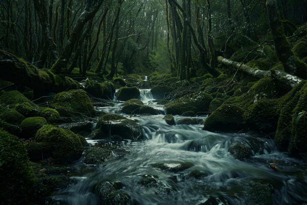
This compact guide lists 10 easy, nature-focused walks and short hikes across Lugo province.
Trails vary from short waterfall approaches and riverside promenades to gentle forest loops.
Use local signposts (PR/SM/SL), and check weather/considitions before heading out.
GPS/GPX tracks are commonly available on platforms like Wikiloc, Komoot and Turismo de Galicia.
Souto da Retorta (Chavín, Viveiro)
Distance: ~2 km loop · Time: 0.5–1 hr · Difficulty: Easy
Highlights: Giant eucalyptus trees (the ‘Avó’), family-friendly, flat paths
Start / Notes: Chavín (Viveiro) — Short, wheelchair/buggy-friendly in parts. Best in spring/early autumn.
Paseo do Río Rato (Lugo city riverside)
Distance: ~3–5 km (depending on loop) · Time: 1–2 hr · Difficulty: Easy
Highlights: Riverside promenade, urban nature, bridges and benches
Start / Notes: Lugo (near Miño riverside) — Good for a gentle walk without leaving Lugo city. Well signposted.
Fraga da Marronda (Baleira / A Fonsagrada)
Distance: variants 5–12 km · Time: 1.5–4 hr (choose short options) · Difficulty: Easy–Moderate
Highlights: Ancient native forest, river Eo tributaries, biodiversity
Start / Notes: Area around Baleira / A Fonsagrada — Several subroutes allow shorter, easy sections. Rustic terrain.
Ruta da Marronda — Alto Eo (PR■G 145, sections)
Distance: split into short sections (3–8 km per section) · Time: 1–3 hr per section · Difficulty: Easy (on shorter sectioHighlights: Source of the Eo, forest paths, remote nature
Start / Notes: A Fonsagrada / Baleira area — Recommended to pick one section for an easy day hike.
Augacaída Waterfall — Ribeira Sacra (Pantón)
Distance: ~2–4 km (roundtrip) · Time: 1–2 hr · Difficulty: Easy
Highlights: Fervenza (waterfall), riverside views, small picnic spots
Start / Notes: Marce / Pantón (Ribeira Sacra) — Short trail to viewpoint; combine with Ribeira Sacra viewpoints.
Ribeira Sacra — short vineyard/river viewpoint walks
Distance: 2–6 km options · Time: 1–2.5 hr · Difficulty: Easy
Highlights: River canyons, terraced vineyards, viewpoints over Sil/Miño tributaries
Start / Notes: Various: Parada de Sil / O Saviñao / Pantón — Pick short, marked PR routes or viewpoint walks for easy

Serra do Xistral — easy access loops (Coto da Lagoa area)
Distance: ~3–6 km loops available · Time: 1–2.5 hr · Difficulty: Easy
Highlights: Peat bogs, highland moor, breathable air, birdwatching
Start / Notes: Valadouro / Coruxos / nearby trailheads — Some sections can be boggy — good footwear recommended.Fervenza Escouridal (Alfoz / Valadouro area)
Distance: ~2–4 km · Time: 1–1.5 hr · Difficulty: Easy
Highlights: Small waterfall, pleasant forest approach
Start / Notes: Roadside near Alfoz (Serra do Xistral foothills) — Short walk from parking; pretty in wet seasons.
Pozo da Ferrería / routes near Baleira (Marronda area)
Distance: ~3–8 km · Time: 1–3 hr · Difficulty: Easy
Highlights: Pools, small waterfalls, native woodland
Start / Notes: Baleira / Fraga da Marronda access points — Good combination with other Marronda short sections.
Loio River walk (PR■G 14 nearby sections)
Distance: ~4–8 km options · Time: 1–2.5 hr · Difficulty: Easy
Highlights: Riparian forest, shaded trail, close to Camino routes
Start / Notes: Near Lugo province PR■G 14 signposts — Well-marked on Turismo de Galicia’s walking network.
Selected sources & where to find GPX tracks: